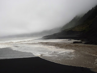
Are you prepared for deep stream crossings, heavy rains,
gale force winds, and hazardous sea conditions?
Leave No Trace principle #1 is to Plan Ahead and Prepare:
“Poor planning often results in miserable campers and damage
to natural and cultural resources. Rangers often tell stories of campers they
have encountered who, because of poor planning and unexpected conditions,
degrade backcountry resources and put themselves at risk.”
Before you go know:
1. The streams in the King Range can rise rapidly following
heavy and persistent rains. However, streams may recede to a safe crossing level within a day or several hours
after it has stopped raining. Of course, this depends on how long and heavy it
has been raining for. It is not advised to attempt a stream crossing that is
deeper than knee height. If this is the case you may need to wait for the
stream to subside to a safer level or turn around and go back.
Shipman Creek, Winter 2012
I am occasionally asked if one can take an overland route
around the creeks if they are too high to cross. In theory this is possible. Yet,
to get up high enough to actually find a place to avoid the stream crossing
would add considerable time and energy to your trip. Are you prepared for an
extra day or two of hiking? This isn’t a quick fix and most likely this is not
something you would want to attempt.
2. Large waves with high energy can race far up the beach –
sometimes without warning. This can make the sections of trail that are
“impassable at high tide” (check a BLM King Range map) increasingly difficult to pass. It is tough to say
exactly that at a sea condition of X and a tide level of X the trail becomes impassable.
However, expect that if there are hazardous sea conditions
reported you will want to pass these sections of trail at the lowest tide
possible and they will become increasingly hazardous. Also, sections of trail
that are not marked as “impassable
at high tide” can also be hazardous. The picture below is Telegraph Creek
meeting a surge of ocean water at Black
Sands Beach
(not marked as impassable at high tide). Use your best judgment. Pay attention.
Possible Situations:
I’ve either witnessed or heard of all of the below scenarios
happening to people.
1. You’re hiking along the Lost Coast Trail in light rains
and the streams are high but still passable. On Day one of your hike heavy
rains set in and persist through the night. On day two you realize that you’re
unable to go north or south because the creeks are impassable. This adds an
extra day to your journey that you didn’t plan for as you wait for the streams to lower.
2. The creek is pretty high but you decide to attempt the
crossing. Half way across you slip and are soaked head to toe – along with most
of your gear.
3. A wave with intense energy races much farther up the
beach than you expect and you jump up onto a small rock ledge at the last
moment and cling on to whatever you can grab. The wave hits and knocks your
feet off the rock but you’re still holding on. You’re now soaked and have a badly
bruised knee.
4. You’re crossing a creek when a large wave surges up the
beach and into the creek - You’re knocked down and get tumbled around between the two forces of water.
5. Gale force gusts of wind wreck your tent leaving you out
in the rain and forcing you to hike out in the night wet and miserable – if the tides permit.
With all this being said, you may have a great and wonderful
trip and you may find exceptionally nice weather between winter storms. But, this is a rugged and wild place and you should prepare accordingly.
Plan to get yourself out of the situations you put yourself
into.
I know what the conditions may have been yesterday or a week
ago – but things change, sometimes quickly and drastically for better or worse.
You’ll need to use your best judgment
based on the conditions and the skills/abilities of your group. Look up, look
around, pay attention, study the waves and the behavior of the ocean.
Use the following links to help plan your trip:
14 day precipitation forecast – one of my favorites but
changes often so check back frequently leading up to your trip. Tip: let the model
run all the way through then you can stop it and click through step by step.
Look up at the top for the date and hour.
Give me a call or send me an e-mail if you have any questions.
707-986-5405
lostcoastranger@gmail.com
Your Wilderness Ranger,
Paul


Great image of Randall Creek! Woo that's a wave.
ReplyDelete